When you click on links to various merchants on this site and make a purchase, this can result in this site earning a commission. Affiliate programs and affiliations include, but are not limited to, the eBay Partner Network.
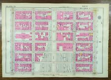
Offering a fine group of original 1893 folio maps from the \"Atlas to Accompany the Official Records of the Union and Confederate Armies\", a comprehensive record of detail during the four years of the Civil War. 29-1/2\" x 18-1/2\". These are in overall very good antique condition. Never openly sold, being distributed only to Federal depositories & other institutions. Original, single fold as issued.FEATURING here an original 1893 lithograph plate CXXVI featuring 11 assorted images circa 1865. Some accompanied the report of Capt. Poe, Corps of Engrs, U.S. Army. Several images of the infamous Confederate Libby Prison where 1000 Union Army prisoners were kept under harsh conditions. Others depict rebel forts in Atlanta, including one with General Sherman. This piece is in good overall antique condition, small separation on top & bottom fold, age yellowing with edge wear/tear to the outer border margins. Please see photos for details. History of the atlas in our description. Home
- Lucy & Desi
- Christmas
- Halloween
- Items On Sale
About UsNewsletterLucy & DesiChristmasHalloweenItems on SaleMenu Store Categories
- Art
- Books Magazines
- Cars & Automotive
- Christmas
- Clothing & Accessories
- Crafts & Sewing
- Disneyana
- Dolls & Bears Modern
- Dolls & Bears Vintage
- Entertainment Memorabilia
- Father\'s Day
- Glass
- Halloween
- Jewelry
- Modern Decor
- Mother\'s Day
- Pottery
- Silver
- Toys
- Other
Product Description Offering a fine group of original 1893 folio maps from the \"Atlas to Accompany the Official Records of the Union and Confederate Armies\", a comprehensive record of detail during the four years of the Civil War. 29-1/2\" x 18-1/2\". These are in overall very good antique condition. Never openly sold, being distributed only to Federal depositories & other institutions.
- FEATURING here an original 1893 lithograph plate CXXVI featuring 11 assorted images circa 1865.
- Some accompanied the report of Capt. Poe, Corps of Engrs, U.S. Army.
- Several images of the infamous Confederate Libby Prison where 1000 Union Army prisoners were kept under harsh conditions.
- Others depict rebel forts in Atlanta, including one with General Sherman.
- This piece is in good overall antique condition, small separation on top & bottom fold, age yellowing with edge wear/tear to the outer border margins.
- Will be shipped in a tube for safety.
- See them all; Happy to combine shipping for extra savings. Click here for other Atlas maps
HISTORY: Original folio map of \"The Atlas to Accompany the Official Records of the Union and Confederate Armies\" commissioned and published by Resolution of the United States Congress of May 19, 1864. Entered as the historical record into the Library of Congress. The atlas illustrated therein a comprehensive record of all battles, skirmishes, troop positions, and an intricate geographic and topographic detail of all four years of conflict. The atlas was never openly sold, being distributed only to Federal Depositories, Universities, Libraries, Museums, and other Public Institutions. Only during the last century were the maps released into the public domain. Of the 10,000 published, fewer then 1,000 complete atlases remain.
Original 1893 lithograph plate from “The Official Atlas to Accompany the Official Records of the Union and Confederate Armies”. Commissioned by Resolution of the United States Congress of May 19, 1864; by which Adjt. General Townsend was Appointed Director of its Collection and Preparation. Upon the passing of General Townsend, the Compilation and Accumulation of maps and records continued through three Presidential Administrations and under the direction of three Secretaries of War: the Hons. Redfield Proctor, Stephen B. Elkins, and Daniel S. Lamont, and attended by its Board of Publication led by Major George B. Davis, U.S. Army, Leslie J. Perry, and Joseph W. Kirkley. They ultimately compiled and published between the years 1891 - 1895 under Captain Calvin D. Cowles in two maroon folio volumes with the publication of 35 parts set in 5 lithograph plates, totaling 175 . Each was engraved by Master Printer Julius Bien & Company. The compilation and assembly of the atlas taking over 30 years to complete.Testimonials
I entrusted my mother and father\'s (Lucille Ball & Desi Arnaz) memorabilia to Connectibles, and during the entire evaluation and sale process, never for a moment did I feel anything less than completely confident, protected and guided by experienced and compassionate professionals who love what they do. We got wonderful results and the best part... it was great fun!\"
- Lucie Arnaz
Payment InformationThank you for choosing to shop with us at Connectibleswhere we guarantee 5 Gold Star Satisfaction!Shipping PolicyWe ship within 24 hours of payment whenever possible as we know you are eager to receive your purchase.
We only charge actual shipping costs and do NOT add handling fees.
Happy to do combined shipping whenever size permits.Terms of SaleWe strive for FIVESTAR Service in our descriptions, communication, shipping speed & costs!
We know you have many choices on , & are more appreciative that you have chosen to shop with us.Tips for International CustomersPlease Note: We love selling Internationally,as shown in our Store Map below! Please note that Import duties aren\'t included in item price & shipping fee. These are the buyer\'s responsibility.
- Please check with your customs office to see what these additional costs may be before offerding.
- Thank you for your understanding. Pleasecontact usif any questions.
Home | About Us | Newsletter | Art | Collectibles | Clothing & AccessoriesCopyright © 2017 Connectibles , All rights reserved.Showcase your items with Auctiva\'s
Listing Templates!
THE simple solution for sellers.
Track Page Views With
Auctiva\'s FREE Counter